Manaus Agile Amazonas tourism and culture
General Data about the city of Manaus

Manaus is a historic city and port. It is located in the center of the largest tropical forest in the world, near the Equator, at the confluence of the Negro and Solimões Rivers, which makes it possible to see a beautiful natural phenomenon known as the 'Meeting of the Waters'.
According to the Treaty of Tordesillas - signed between Portugal and Spain, the region of the current state of Amazonas belonged to the Spanish. It was only in 1750, with the Treaty of Madrid, that the Portuguese took definitive possession of the region.
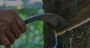
In 1888, rubber exploration brought prosperity, luxury and wealth. Manaus was the second city to receive electricity (the first was Campos dos Goytacazes, in Rio de Janeiro State), and the first to be urbanized with rainwater galleries, water and sewage treatment, electric tramway service, and inaugurated its first University in 1909. Besides great works, such as the Amazonas Theater, the Adolpho Lisboa Market, the Palace of Justice, the Rio Negro Palace and the Customs House. But it was from 1910 on, with the entry of Asia into the rubber market, that Manaus entered a bitter period of decadence and abandonment. The rebirth of the region happened after the 20th century, with the creation of the Manaus Free Trade Zone.
Today, Manaus stands out as the main financial, corporate, and economic center of the Northern Region of Brazil. It is also the most populous city in the Amazon, with a population of nearly 2.1 million, according to estimates by the Brazilian Institute of Geography and Statistics (IBGE) in 2016.
- Founding: October 24, 1669 (350 years old).
- Federative Unit (UF): Amazonas
- Gentile: Manauense and Manauara
- Direct Dialing Distance (DDD): 92
- Bordering municipalities: North: Presidente Figueiredo |. South: Careiro and Iranduba | East: Rio Preto da Eva and Itacoatiara | West: Novo Airão
- Patroness: Nossa Senhora da Conceição
- Current mayor: Arthur Virgílio do Carmo Ribeiro Neto (PSDB) 2017-2020
CHARACTERISTICS GEOGRAPHICAL
- Area: 11,401.092 km²
- Altitude: 92m
- Climate: Tropical (equatorial, hot and humid)
- Density: 183.7 hab/km²
- Time zone: UTC-4
- Population: 2,094,391 inhabitants (http://cod.ibge.gov.br/3WL) population estimate - IBGE/2016)
INDICATORS
- Municipal HDI - 2010: 0.737 (Source: IBGE - Brazilian Institute of Geography and Statistics)
- GDP per capita at current prices - 2014: 33,446.76 reais